John Crump House Historical Report, Block 17 Building 3B Lot 57Originally entitled: "Report on Red Lion Inn Block 17"
Colonial Williamsburg Foundation Library
Research Report Series - 1331
Colonial Williamsburg Foundation
Library
Williamsburg, Virginia
1990
REPORT ON RED LION INN, BLOCK #17.
October 14, 1930.
obsolete
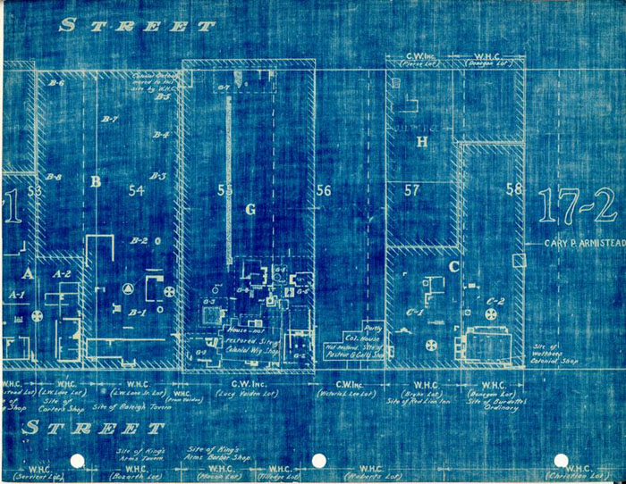
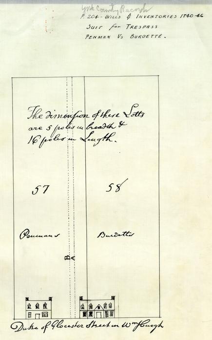
The appended plat plan of the Colonial lot divisions of the modern Block #17 locates the site of the Red Lion Inn and the other buildings east of it according to new data from the Yorktown records. The blue print of a tracing from the York records in a crude sketch of the Red Lion Inn (Penmen's) as it appeared in 1743 when Penman was involved in litigation with Burdette who encroached on his property.
Although this new evidence corrects some of the evidence in the prior report (August 27, 1930) the site of the Red Lion Inn is approximately the same.
The Yorktown data checks perfectly with the Frenchman's map - the earliest data, of course, plotting on only a portion of the lotts, but building or lot dimensions check with this map made in 1786.
For examples the block is 675 feet long from Botetourt to Capitol Square. Botetourt Street in 60 feet wide; the lots are 82½ feet wide on Duke of Gloucester Street, with smaller subdivisions being made at intervals. These facts hold true for the Frenchman's map, for old buildings still in existence, and for sites of buildings mentioned in York records that are shown on the map.
The following record of ownership and tenancy of the Red Lion Inn is compiled from the new Yorktown records and from the Virginia Gazette notes of Miss Goodwin: 2
3Thos. Penman, an innkeeper leased the lot for 7 years from John Sharp in 1741 for a yearly rent of£ 8. There were a number of important building stipulations in the lease, namely - a brick chimney was to be built to the "Billyard house"; a house 20 x 16 feet was to be erected by Penman, but Sharp was to build the chimney; a kitchen 16 x 12 feet with a brick chimney was to be built by Sharp. The back shed then standing on the lot adjoining the "Mansion House" was to be razed and built 2 feet larger by Sharp. The whole lot was to be paled and all houses to be in good repair by March; a smoke house was to be erected by Christmas. When Sharp had fulfilled these conditions the yearly rent was to be£ 10.
On October 1, 1742, John Sharp conveyed the lot to Henry Wetherburn, tavern-keeper, describing it as the "messuage" house and lot #57 now in the tenure of Thos. Penman".
A dispute over the boundaries of lot #57 and #58 occurred in 1743 between Thos. Penman, whose lott was then tenated by Seth Lukright, and Burdette, the owner lot #58. The city surveyor, Jos. Davenport was called in and determined the following on May 16; (with reference to the appended tracing of the original drawing in the Will and Inventory Book) "it appears that the Body of the defendent's (Burdette's) houses, stands about 8 feet upon the plaintiff's (Penman's) lotts. The pricked line A shows the bounds of Burdette's lott as held by by Mr. Kerr, taking in all 14 feet from the said Penman's lott and the pricked line B taking about 4 feet more, was lately a line of pales of the said Burdette."
In Thos. Penman's will recorded in 1759 he leaves his widow the messuage house and lott now occupied by James Craig. The lott was advertised for sale in the Virginia Gazette of December, 1774, being described as the property of Thomas Penman, deceased.
The next record of the building, in August, 1778 was when it was conveyed by John Lewis to Cornelius de Forrest, being the lot where the said Lewis lived.
According to the map made by plotting this data by the dimensions in the York records and from the buildings indicated on the Frenchman's map-, the Red Lion Inn at the present time is under the Bryhn house about 4 feet from the present Lee house, and east along Duke of Gloucester Street 50 feet. Excavations made in this section would uncover the foundation.
The foundation partially uncovered at the present time under the Donnegan house is the old "Burdette" foundation.
Additional data is available on these two buildings in the Wills and Inventories of Penman and Burdette, which lest the rooms in their respective houses and the furniture therein. These are now being copied at Yorktown and will be issued as a supplement.
h.d.b.
REPORT OF THE RESEARCH STAFF ON RED
LION INN- August 27, 1930
BLOCK #17, Lots #2 & #3.
John Crump House
Bldg 38
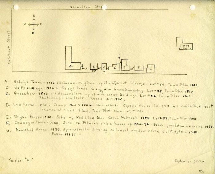
The research staff has investigated the theory that the "Red Lion Inn" was located on the site of the present Donnegan house, Block #17, Lot #2. The result is that no evidence can be found to support this theory, whereas there is abundant evidence to prove that it is located just to the west, on the sit of the present Bryhn house, Block #17, lot #3.
A picture of the "Red Lion Inn" (owned by Miss Annie Galt), was seen by Miss Joan Etheredge recently who reported that it was between the present Lee and Donnegan houses (on Bryhn's site). The Lee family also remembers this building next door as it was razed about thirty years ago. Other townspeople also locate the building here, and Mr Charles in "His Recollections of Williamsburg" states the following:
"On the site now occupied by the new dwelling owned by Mr. Bryhn, and the house next to the Cogbill house, there stood up to a few years ago, a long one story and a half frame building with dormer windows, and two doors opening on the street. The up-town door was the entrance to the part used as a dwelling, and the down-town door was the entrance to the store once kept there. This house was the original 'Red Lion'. This old 'Red Lion' was evidently one of the originals. On account of its age it became delapidated and a menacing fire trap, and it was removed not many years ago." (Page 48, P. 1 & 2).
There are four sources of evidence available to determine this site, no one of which would be conclusive by itself. We have had to add all this evidence stretching over a period of about fifty years. When this was done, dimensions determined in this way were used to determine unknown dimensions. The dimensions thus established conformed to all evidence, historical, archaeological, and surveyor's. The chain of evidence by which these conclusions were reached follows, in reverse chronological order, the way in which it had to be obtained:
21806:
The known quantities in Block #17 were Raleigh Tavern and a little building between the present Vaiden and present Lee houses. This was a small building which was torn down about 20 years ago, but the Lee family has given this office a photograph of it. This building was owned by Robert Greenhow in 1806, who insured it in Policy #645, at which time he described it as being 10 feet from Crump's dwelling on the east (the present Lee house is 10 fee from this foundation.) and 20 feet from Dr. Galt's house or shop to the west. The building was described as 20 feet long (on Main Street) and 34 feet deep. Dr. Galt's house was mentioned in an insurance policy #666 on May 27, 1806 for Raleigh Tavern as being a wooden building 30 feet distant on the east from Raleigh Tavern. Since the present Lee house is 10 feet from the Greenhow foundation, and the Greenhow foundation is 20 feet long, there is a 20 foot space between it and Dr. Galt's which by process of elimination makes the Galt foundation (on the Vaiden site) about 33 feet long.
Conclusions:
- 1.Dr. Galt's house west of Raleigh Tavern- 30 feet. Building about 33 feet long. This is on the Vaiden site.
- 2.Greenhow's store of 1806 was the little building razed by the Lees. West of Galt's 20 feet and east of the present Lee house 10 feet.
- 3.Crump's house, 10 feet east of Greenhow's store was the present Lee house.
1800:
According to the Town plot plan of 1800 drawn by B. Bucktrout, the lot numbers and names given for these sites beginning with Raleigh Tavern and proceeding east are as follows:
- Lot # 55- Galt.
- Lot # 56- Greenhow.
- Lot # 57- Crump.
- Lot # 58- Meade.
- -------- Clerk's Office.
Conclusion:
This second step then gives us the lot locations and owner's names in exactly the same order in 1800 as the Insurance Policies give in 1806.
1700-1800:
In 1757 Thos. Penman leaves his house and lot (#57) "now in the tenure of James Craig" to his wife. Craig seems to have bought this lot as it was known as "Craig's lot" as late as 1796, but at that time belonged to Dr. J. M. Galt, who married Craig's daughter. (M.F.G. Book III, Coff.House, p.2, P. 1.)
(Note: Miss Goodwin does not say whether this lot number was mentioned in the will or whether she assumed it from the lot numbers of 1800. It is not stated where the lot was "known" as the Craig lot, nor where the record of a marriage between Dr. Galt and Miss Craig exists.)
In Deeds and Orders #8 : 81 (M. F. G. Notes Book III, Coff. House, p.2, P. 2) no date given, Miss Goodwin says:
Waller sold lot #58 to J. P. Webb, "being bound by the south by Duke of Gloucester Street, on the east by the Capitol, and on the west by the lots owned by Henry Wetherburn, being a messuage house late in the tenure and occupation of John Burdette" except 35 feet square in the east of the lot, belonging to Nathaniel Walthoe. Walthoe left his property to his sisters in England, and Waller as executor petitioned and obtained permission from the Assembly to sell the lots. (Hen. VIII: 627)
There is additional evidence that this lot # 58 at one time belonged to Walthoe in the following:
In the W. & M. Quarterly, XVII: 134, we have a journal of George Fisher, who came to Williamsburg from England in 1750 to make his home. He writes thus: "A large house near the Capitol, known by the name of the English Coffee House 4 being vacant, I took it, but being soon tired of this public business (of keeping tavern -G-) I quitted it and stuck to dealing in Coffee, etc., proposing as my house was large to divide and let it out as tenements. (This was done, after many disagreements with various representative citizens, one of whom was Henry Wetherburn, who had the letting of the tavern at this time.-G-) I reserved also the much better part for my own use! One day, de tells us, afire occurred in the house of Mr. Palmer. "Only Mr. Walthoe's house was between the Coffee House and Mr. Palmer's - - - Between the east end of Mr. Walthoe's and the house on fire was a void space of 30 ft. and the wind directly at the west, a strong gale, there was no great danger, but some gunpowder stored in the house of Mr. Palmer caught fire, and Walthoe's house caught too. The Capitol, distant 200 feet was in great danger. Between the west end of Mr. Walthoe's and the Coffee House was a space four feet wide. "The fire was finally put out without further damage".
April 7, 1768- Walter Lenox, perukemaker, has moved to the house known by the name of the Red Lion next door above Mr. Rind's printing office, where he carries on his business and has good accommodations for lodgers.
Notes, Book II, Va.Gaz. p.11, P. 7.
--M.F.G.
Walthoe's house was between the Coffee House (Lee's) and Mr. Palmer's house. There are the following references to Palmer's house in the Virginia Gazette:
Nov. 18, 1773- For Sale, the lots near the Capitol in Williamsburg held by the heirs of the late John Palmer whereon is an excellent good brick house, two stories high, also a small wooden one, very commodious for a gentleman's study, with two rooms necessary outbuildings. -Lewis Tyler. --M.F.G. Notes, Book II, Va.Gaz. p.29, P. 3.
April 28, 1775- (Purdie's Virginia Gazette) For Sale- the brick house and its appurtenances near the Capitol. In Wills, belonging to the late John Palmer. (John Tyler, Executor.) --M.F.G. Notes, Book II, Va. Gaz. p.33, P. 2.
This spacing of buildings will also correspond to the other locations established, and for the year 1750 means that the buildings described are:
- 1.Crump, house of, 1806, in 1750 was the Coffee House operated by George Fisher.
- 2.The building just to the east was Walthoe's house, just four feet distant from the Coffee House, and 30 feet distant from the next building on the east, the Palmer house. Walthoe's building is the Red Lion Inn (see Charles' Notes, etc.)
- 5
- 3.The Palmer house was on the corner, under the present house #2 on Block #17. The archaeologists report the foundation excavated in this location is of sufficient strength to carry a brick building.
That there was a wooden house, probably a colonial one, between Palmer's brick house and the corner is indicated in the following note of Mr. Charles. This house must have been built after the fire of 1750 previously described.
--Mr. Charles Recollections of Williamsburg- p.48, P 4: The last house on this square facing on Duke of Gloucester Street was upon the present sit of Mrs. D. Armistead's residence and was known as the "Morrison" house. This was a story-and-a-half frame house, with dormer windows. There was a porch along the western end. The front of this old house was about on a level with the street; but was high from the ground at the back. This old domicile was evidently also one of the originals, but being worn out in service it was pulled down in 1883.
 Duke of Glocestor Street in Wmsburgh